Trail Maps
Location
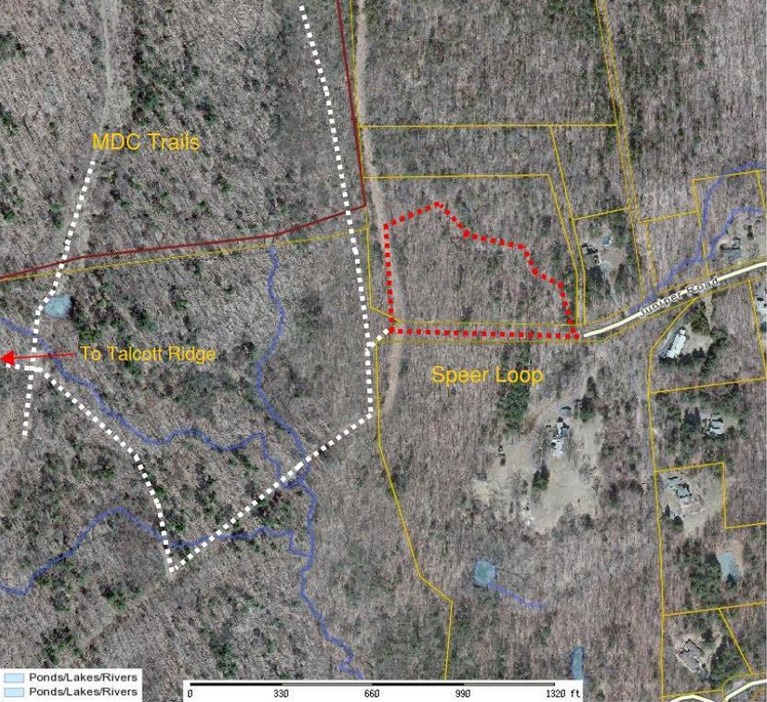
The Speer trail is a loop; this description is the counter clockwise direction. Proceed up the country road to the right. At its end turn left onto the gas line trail heading south until you reach the country road on the left. This road will return you to the parking area.
If one is to continue following the gas line south, this trail will connect to the MDC trail system on the right. Follow signs and one could proceed to the Heublein Tower, Talcott Mountain State Park, and MDC reservoir #6.
Distance
The Speer loop trail is around 1/3 mile. Heublein Tower is approximately 1 mile from the Speer property corner.
Terrain
Moderate slopes
Features
The Speer Preserve is rich with diversity. Hikers will be treated to an upland hardwood forest strewn with boulders, old stone fireplaces, foundations, and remnants of a homestead. Along the gas line trail westward beyond a cliff edge are stunning views, especially in winter. Proceeding onto the MDC trails will open views of the rock cliff that forms the Simsbury/Bloomfield line.
These 13.9 total acres of secluded woodland at the end of Juniper Road were donated in March 1994 and December 2009 by the Nature Conservancy and Edmund and Elizabeth Speer.
Three-season hiking and memorable cross-country skiing. Spectacular panoramic views if one continues on to the Talcott Ridge trail.
Speer Trail
Rating: moderate
Distance: 1/3 mile loop
Access: At the end of Juniper Road which is off of Simsbury Road (Rte. 185).
Parking: Park at the dead end road.
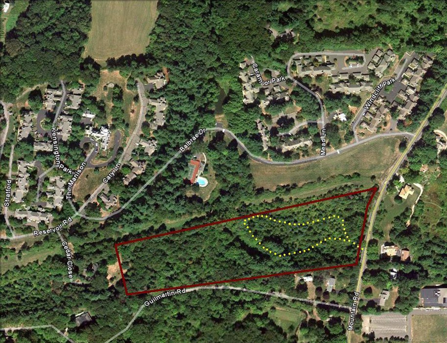
Van Otterloo Trail
Rating: Easy
Distance: 1 mile total
Access: Directly off Mountain Road
Parking: South of preserve, 180 Still Road; not on Guilmartin Road.
Location
Off Mountain Road, park at B’nai Tikvoh-Sholom Synagogue parking lot on the corner of Still Road and Mountain Road. Proceed north across Mountain Road to the opening in the stone wall. From here the trail loops through thick under-brush. An extended hike can be taken if at the waterfall one proceeds across the bridge heading west on an old road. The trail is vague in this region but walking is easy under the large conifer canopy. It is best to return to the bridge to cross the stream.
Distance
The loop trail is 1/2 mile and the extended trail west of the stream is an additional 1/2 mile.
Terrain
Near level to mild slopes
Features
This is a short loop trail that proceeds west to a stream and seasonal waterfall, to complete the loop the trail will follow the stream until it turns east toward the start point.
The trail transitions from new growth forest to old growth towering conifers. Once the bridge is crossed the under story views begin to open up.
To the west of the stream one will also encounter a wetland section in the south-west region of the preserve. Once the trail rises quickly to the west, start to return to the east because you will soon be on private property.
Location
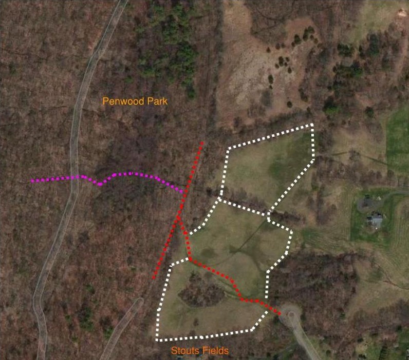
Trail begins directly off of the cul-de-sac. There are two fields with linking bridges where a stream divides them. As you proceed up the main trail head north along the edge of the field into the north field. From there either complete a clock wise loop or proceed to an old country road which will connect to the Penwood Park red trail.
Alternately, one could simply connect to the Penwood park trail system by following the main field trail through the red fence onto the marked red trail. From there possibilities are great however; if you have a desire to connect to the Metacomet Blue Trail proceed north 200 feet on the red trail until you see a purple trail on your left. This trail is moderate incline with short steep sections and it will connect to the Penwood ridge which is the Blue Trail (New England Scenic Trail)
Distance
The meadow loop trails are around 3/4 mile if taken together. The purple trail that connects to the Metacomet trail is about ½ mile long.
Terrain
Near level to mild slopes
Features
These fields are managed upland grassland meadows with views of the Connecticut valley. Both fields provide direct connection to the Penwood Park trail system.
There are views of spectacular fall foliage along the wooded field edges.
Stout Family Fields Trail
Rating: Easy to moderate
Distance: 3/4 mile total loop
Access: At the end of Stone Hill Drive, this is off of Duncaster Road.
Parking: Park on the cul-de-sac
Hawk Hill White Trail
Rating: Moderate
Distance: 3.0 mile
Access: Adjacent to Parking
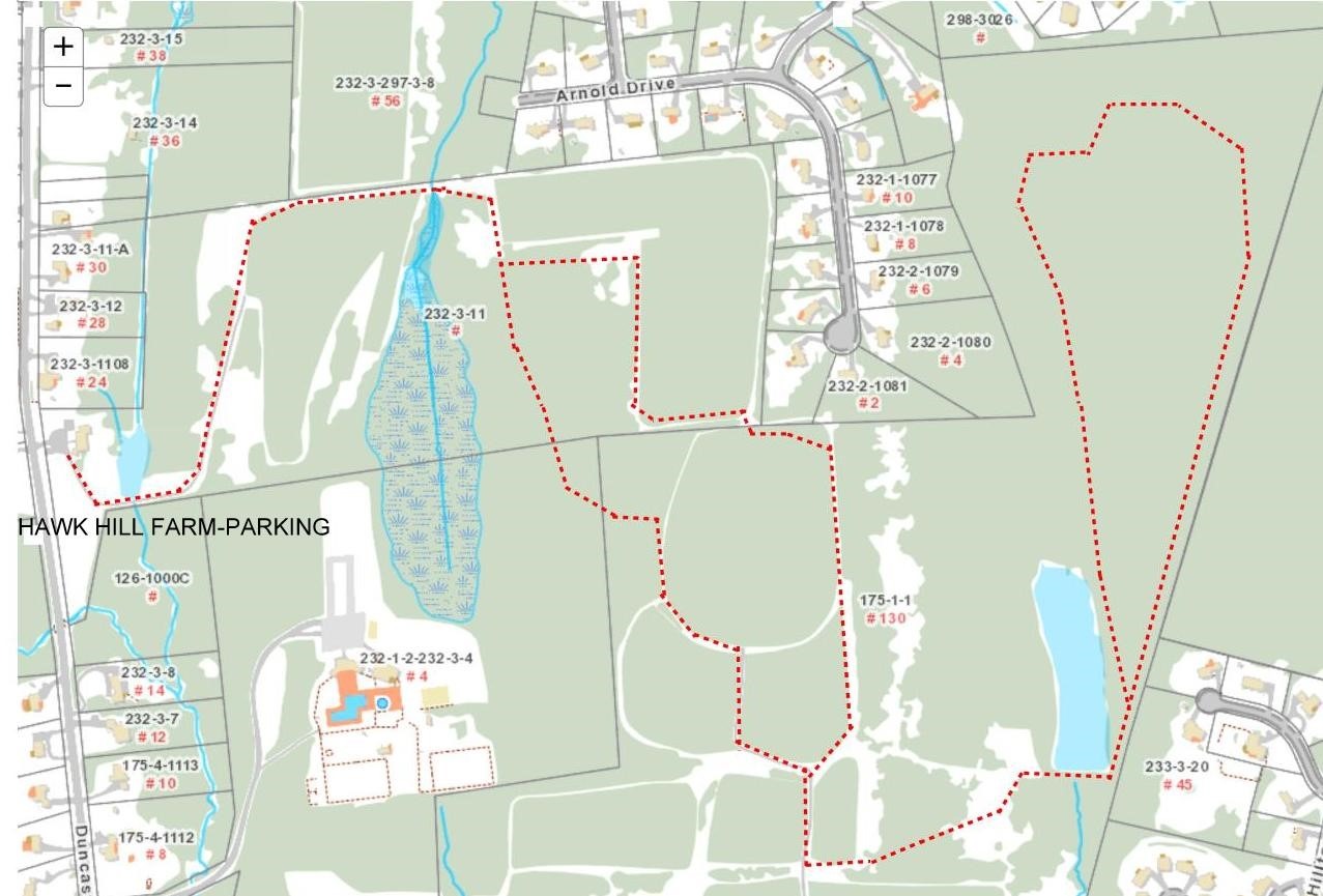
Parking: Hawk Hill Farm Parking
Location
22 Duncaster Road, park at the Hawk Hill Farm yard entrance. Proceed up the Farm road to the main fork and turn left. Follow Farm road into the white marked forest. This will open into the upper fields; proceed south to a left turn- off leading toward the pond. Complete the main loop once past the pond dam. Optional return loop offers more views of the upper pastures and cattle.
Distance
The Hawk Hill trail is 1 mile to the pond; the White loop is 1 mile; the return loop through the upper fields is also 1 mile
Terrain
Mild to intermediate slopes
Features
This White Loop trail includes views of a pristine pond, upland woods, valley and seasonal streams.
The trail crosses the pond dam and proceeds up an incline due north to a high point. The trail loop will be visible on the left, stay right. This high point was once the top of a Town ski run and is the highest point in the center of Bloomfield. Proceed north and the faded red trail marks become visible. Continue to follow the white marks counter-clockwise to proceed along the valley and wetland edge to complete the loop.
Location
Next to # 24 Duncaster Rd. The trail head starts at the cow corral. Follow the farm road up into the pastures. Create a loop around the pastures or continue into the wooded area which will connect to LaSalette Park Trails.
Distance
The loop trail is 3/4 mile and can extend into LaSalette Park Trail system.
Terrain
Moderate slopes.
Features
This trail features a working farm with Highland cattle grazing in the pasture land. Views of the surrounding hills become apparent as the trail rises to the upper pasture. At the upper pasture near the LaSalette Park one can see on clear days the Seven Sisters Range in North Hampton, Ma.
Hawk Hill Trail
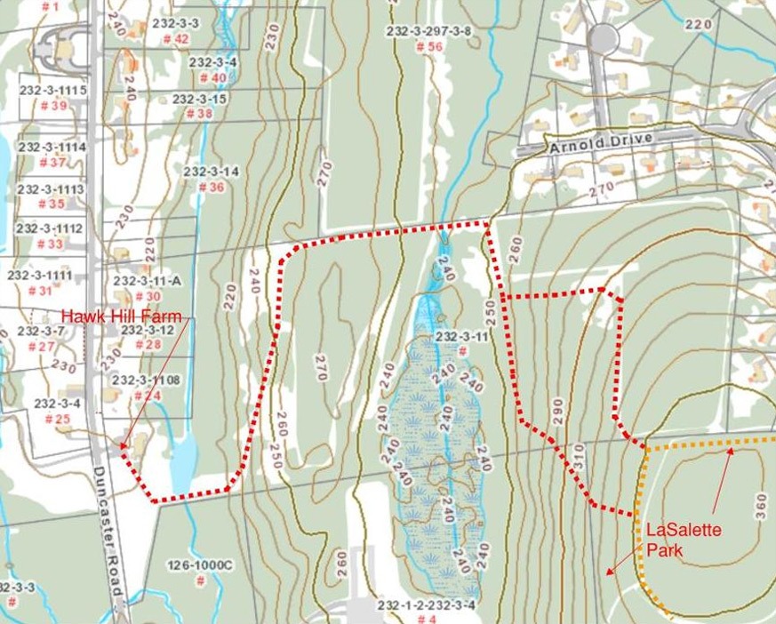
Rating: Easy to Moderate
Distance: 1.25 mile
Access: Directly off Duncaster Road
Parking: Park at the Farm in front of the cow pen
Seabury Wildwood Trails
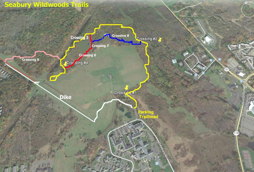
Rating: Easy
Distance: Long loop- Yellow to Pink to White – 2.6 miles
Access: Wintonbury Ave. to Seabury Drive to the Trailhead
Parking: Park at the trailhead
Location
The location, known as Reservoir #2, is State land, leased to the Town for passive recreation. The land was formerly the home of A.C. Peterson Dairy until the State acquired it for flood control purposes (remnants of farm equipment ‘put out to pasture’ can be seen occasionally from the trails). Reservoir #2 is also host to the Wintonbury Flying Club whose members can be seen nearly any day flying remote control model planes.
Distance
Yellow Trail – 1.1 miles
Blue Trail – .2 miles
Red Trail – .3 miles
Pink Trail – .5 miles
Dike (white) – 1.0 mile
Terrain
Easy slopes, mild elevation change
Features
Several small brooks pass through the area and are crossed by eight bridges noted on the map. The Trails pass through meadows, huge oak and hemlock forests and numerous strands of juvenile white pine. Seasonal wild flowers abound in the meadows and along the brooks. The Wildwoods Trails were developed and are maintained by residents of the Seabury Active Life Community. The trails, begun in 2006, are still a work-in-progress as one more bridge and boardwalk will be built, and more signage and benches will be added.